Via Algarviana – walking and cycling route through the Algarve | route + tips
Via Algarviana – walking and cycling route through the Algarve | route + tips
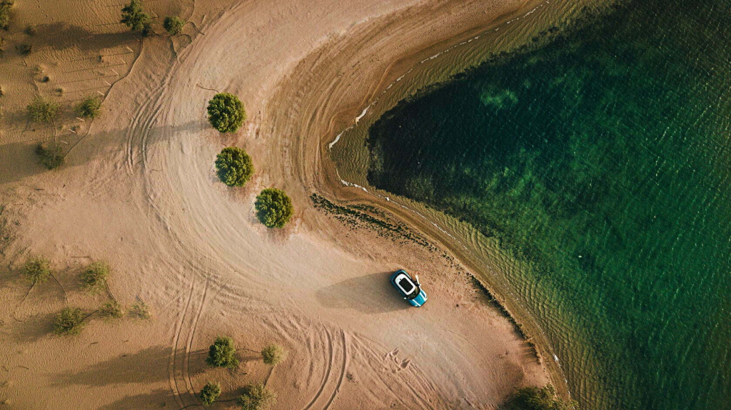
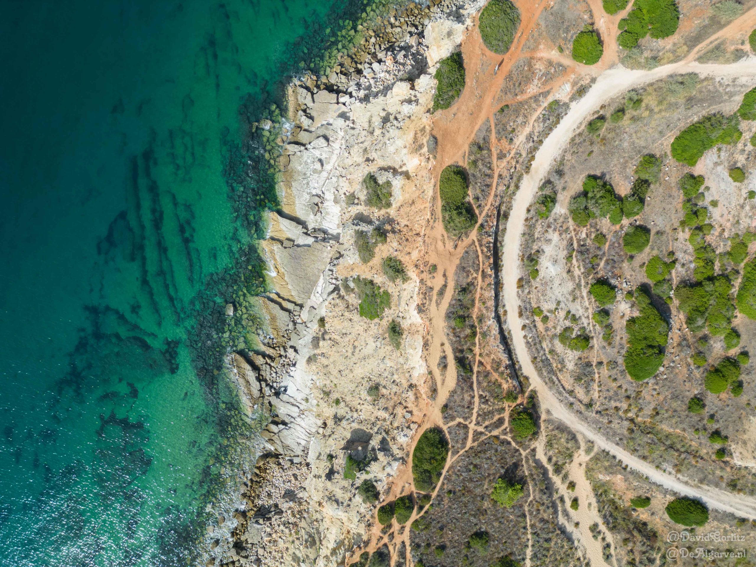
The Algarve is rich in beautiful hiking trails that take you along the impressive coastline and the idyllic interior of Portugal. One of the most popular routes is the 300 kilometre long Via Algarviana . This cycling and hiking trail runs from Alcoutim in the east of the Algarve to the Cabo de São Vicente in the west and is well signposted with signposts and information boards. On this page you will discover everything you need to know if you are going to walk or cycle along the Via Algarviana in the Portuguese Algarve.
Via Algarviana map and overview
The Via Algarviana is divided into 14 stages and can be walked or cycled in both directions. Most walkers choose to start in Alcoutim in the east and finish at Cabo de São Vicente in the southwest. The route was originally designed for walkers, but can also be done by mountain bike or even on horseback. Below you will find an image of the map and the stages:
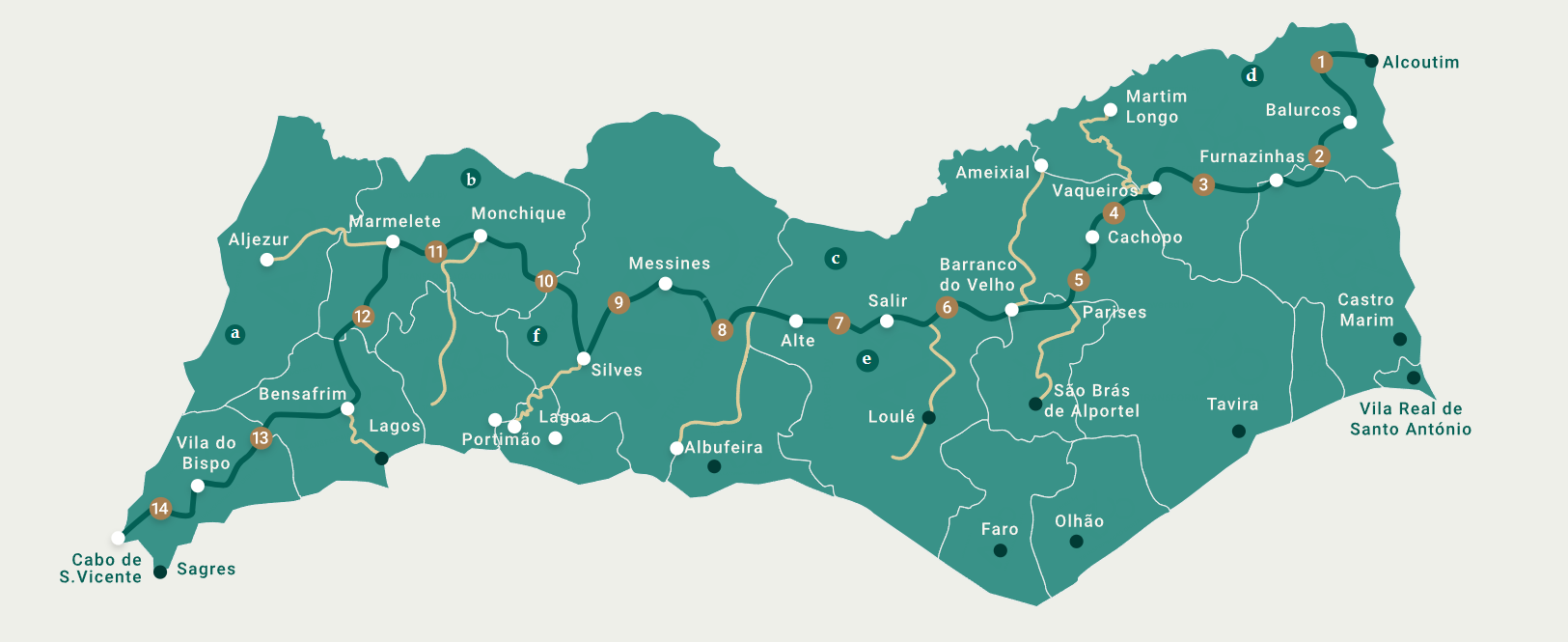
The route is divided and constructed in such a way that you have multiple overnight options at each end point and occasionally encounter shops. Some stages are longer than others, but this is mainly due to the vertical distances that you will cover. Days with more elevation are often shorter in terms of number of kilometers.
About the route of the Via Algarviana
What can you expect during your Via Algarviana adventure?
The journey begins at the scenic point where the Guadiana River meets Alcoutim, and takes you through the Serra do Caldeirão mountains, a region famous for its cork production. Here you will find charming villages such as Salir, Benafim, and Alte, all of which are worth exploring. As you continue towards São Bartolomeu de Messines, the path crosses the historic Ribeira do Arade River.
A visit to medieval Silves is an absolute must before continuing to the Serra de Monchique mountains. The latter offers breathtaking viewpoints from the Algarve’s two highest peaks: Picota and Fóia. The route then takes you through unspoilt nature to Marmelete, Bensafrim and Barão de São João, crossing a dark green pine forest along the way.
The scent of the sea becomes stronger as the Via Algarviana approaches its end point in the Parque Natural do Sudoeste Alentejano e Costa Vicentina. This natural area is known as one of the best preserved coastlines in Europe, making it a worthy end to your adventure.
Watch the ‘trailer’ of the Via Algarviana here:
Via Algarviana stages and distances
The table below shows the 14 stages and the distances of the Via Algarviana from east to west . The distances per stage vary from 14 to 32 kilometers per day. If you are an experienced hiker or want to complete the route in fewer days, choose to complete multiple stages in one day. Below the table you will find my suggestions for completing the route in fewer days.
| Day# | from | to | Distance (km) |
|---|---|---|---|
| 1 | Alcoutim | Balurcos | 24,2 km |
| 2 | Balurcos | Furnazinhas | 14,3 km |
| 3 | Furnazinhas | Vaqueiros | 22,6 km |
| 4 | Vaqueiros | Cachopo | 14,8 km |
| 5 | Cachopo | Barranco do Velho | 29,5 km |
| 6 | Barranco do Velho | Salir | 14 km |
| 7 | Salir | Alte | 16,4 km |
| 8 | Alte | São Bartolomeu de Messines | 20,6 km |
| 9 | São Bartolomeu de Messines | Silves | 29 km |
| 10 | Silves | Monchique | 32,1 km |
| 11 | Monchique | Marmelete | 14,8 km |
| 12 | Marmelete | Bensafrim | 30 km |
| 13 | Bensafrim | Vila do Bispo | 29,7 km |
| 14 | Vila do Bispo | Cabo de São Vicente | 16,4 km |

Via Algarviana overnight stays – Hotels, B&Bs and accommodations along the route
The Via Algarviana is laid out in such a way that there are a number of accommodation options at the end of each stage. The exception to this is Cachopo, at the end of stage 5. You can choose to continue on the next stage, try to arrange a taxi to a nearby accommodation or deviate from the route.
Although most places have a few hotels and B&Bs, especially in the smaller places the number of rooms is limited. If you want to do the Via Algarviana in high season, I recommend booking your accommodation a few months in advance. In low season, a few days or a week in advance is often sufficient.
In the table below you will find an overview of recommended hotels and B&Bs to stay in per stage. For each location (end of a stage) you will find a budget option and a ‘more luxurious’ option, if available. Click on the name to view the hotel on booking.com:
| Place name | Budget hotel, apartment or hostel | Luxery hotel of apartment |
|---|---|---|
| Alcoutim | HI Alcoutim – Pousada de Juventude | Hotel D’Alcoutim |
| Balurcos | Casa do vale das Hortas | Charming Countryside Home |
| Furnazinhas | Varandas do Vale Furnazinhas | Varandas do Vale Furnazinhas |
| Vaqueiros | Casa das Bonecas | Casa das Bonecas |
| Cachopo | n/a | n/a |
| Barranco do Velho | Casa De Campo Cantinho Da Serra | Casa De Campo Cantinho Da Serra |
| Salir | Monte Carrascal Guesthouse | Casa do Torreão |
| Alte | Alte Tradition Guest House | Casa Barroca |
| São Bartolomeu de Messines | 20 da Vila – Messines Valley | Bartholomeu Guesthouse |
| Silves | Ponte Romana | Mosaiko 5 Suites |
| Monchique | Casa dos Batalim | Alojamento S. Gabriel 1 |
| Marmelete | Casinha Laranja | Casinha Laranja |
| Bensafrim | Agua de Sonho | Casa Joia by Seewest |
| Vila do Bispo | Pure Fonte Velha B&B | Pure Flor de Esteva |
| Cabo de São Vicente (Sagres) | Blacksheep Sagres Guesthouse & Surf | Cercas Velhas |

Via Algarviana – Preparation, packing list & tips
The Via Algarviana is a beautiful hiking trail that will undoubtedly stay with you for a long time, whether you walk the entire route or just part of it. In any case, good preparation before you start this adventure is very important, as it is a considerable distance and you may not have cell phone reception everywhere.
These are the most important tips I want to give you before you start the Via Algarviana:
- Consider the climate: The Algarve has a Mediterranean climate with warm summers and mild winters, but the weather can change quickly in the autumn in mountainous areas. Be prepared for different weather conditions by dressing in layers outside of the summer and always carrying a light raincoat or poncho.
The summer months can be extremely hot, so avoid walking during the hottest part of the day (11am-1pm) and make sure you carry plenty of water to prevent dehydration. Winter can be cooler and wetter, so make sure you wear waterproof clothing and shoes.
The best times to walk the Via Algarviana are in early autumn and spring. Not only is it less hot, but the nature will be in full bloom after it has rained - Plan your route: Make sure you know in advance which stages you are going to walk and where you will be staying. Take into account the distances and estimated walking times to set realistic goals. Remember that the Algarve is hilly and you will therefore also cover a lot of vertical kilometers.
Print out the routes or save them on your phone. In the latter case, consider a power bank so that you never run out of power.
Download the Via Algarviana app (Android/iOS) to consult the map and have information about the routes at hand while travelling. - Pack smart: Only take what you need. This should be on your packing list :
- A good hiking backpack, ideally with a hip belt;
- Well run in hiking boots;
- Light and breathable clothing;
- Breathable rain poncho in winter;
- Essential items for sun protection such as sunscreen, polarized sunglasses and cap/hat;
- Sufficient food and drink for the journey;
- Water bottle of at least 1 liter;
- First aid kit including (blister) plasters and disinfectant;
- A pocket knife is always useful;
- Inform someone about your plan: Tell a family member or friend about your plan and give them a copy of your schedule. Check in with this person regularly. If something unexpected happens, someone will know your last location.
- Good walking shoes: Invest in a pair of comfortable and sturdy hiking boots. Make sure you break them in before you start the route to prevent blisters.
- Be aware of the sun: The Algarve can be very sunny, so make sure you take plenty of water and take regular breaks to rest in the shade.
- Take local contact numbers and be aware of forest fires : Make sure you have the telephone numbers of local emergency services and the accommodation where you are staying.
The emergency number in Portugal is 112. If you see a forest fire, call 117.
In summer, keep an eye on the website fogos.pt to stay informed of any forest fires. - Train for the hike: Make sure you are in good physical condition by training beforehand, especially if you plan to hike for several days in a row.
- Learn basic Portuguese: Although many people in the Algarve speak English, it can be useful to learn some basic Portuguese for the more remote areas, especially if you need to ask for directions or check in to your accommodation.
- Respect nature: Do not leave any waste and respect local flora and fauna by staying on the paths. Open fires are prohibited.
Via Algarviana stage 1: Alcoutim to Balurcos
Stage 1 of the Via Algarviana runs from Alcoutim to Balurcos and is 24.2 kilometers.
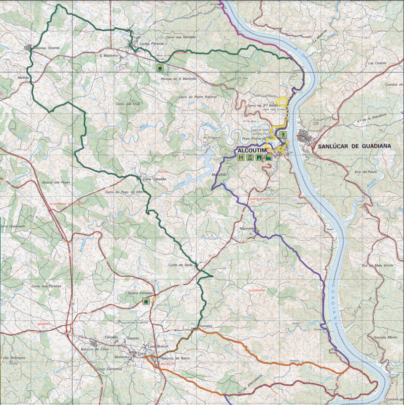
You start your Via Algarviana adventure at the pier of Alcoutim, with the impressive Guadiana River as a backdrop. The route crosses the town and continues north, passing rural orchards full of carob, almond, fig and olive trees along the way.
Soon you leave the river behind you and head inland towards Cortes Pereiras, after which you continue to the Lavajo Menhirs. The path takes you further south through forests and hilly terrain, until you reach the Alcoutenejo Gorge. You follow the route southeast to Corte Tabelião and finally to Ladrões Gorge.
Along the path you will come across typical Portuguese houses, as well as traditional vegetable gardens of the locals surrounded by stone walls. Finally you will reach Balurcos, where this first stage ends.
Please note that there are almost no guest accommodations in Balurcos, so you will have to stay just outside the village or circle back to Alcoutim for the night.
Via Algarviana stage 2: Balurcos to Furnazinhas
Stage 2 of the Via Algarviana runs from Balurcos to Furnazinhas and is 14.3 kilometers.

The second stage of the Via Algarviana starts in the small hamlet of Balurcos in the municipality of Alcoutim. The route descends south along rural paths, dotted with stone walls around small farms. The terrain soon becomes hilly, typical of the Algarve hinterland, with streams cutting through the landscape.
After crossing the IC-27 road, the landscape changes and you walk along the Foupana river, one of the most idyllic waterways of the Algarve. In Palmeira you will see typical rural architecture. The route then takes you to the ruins of the old water mill “Moinho da Rocha do Corvo”.
After crossing the river, the steepest and longest climb of this stage follows through a holm oak forest to Corte Velha. All around you, you see the hustle and bustle of agriculture and cattle breeding. You also come across dilapidated windmills and well-preserved threshing floors.
The stage ends in Furnazinhas, a beautiful mountain village in the rural Algarve.
Via Algarviana stage 3: Furnazinhas to Vaqueiros
Stage 3 of the Via Algarviana runs from Furnazinhas to Vaqueiros and is 22.6 kilometers.

The third section of the Via Algarviana starts in Furnazinhas and leads through a rugged landscape of fields, broom bushes and the occasional vegetable gardens of the locals. The terrain is hilly and is crossed by several small watercourses. Along the way you will come across some almost deserted settlements, such as Monte Novo and Monte das Preguiças, where a table with benches by a small reservoir is a perfect place to take a break. Note the beautiful traditional houses in Malfrades as you continue to Vaqueiros.
At the fire watchtower you can enjoy a 360° panoramic view. The route continues with some ascents and descents, coinciding with the PR8 ACT path for the last 3 km of this section. At the Vaqueiros Dam you will find the Fonte da Parra picnic area, perfect for a snack with a view of the dam. In Vaqueiros, located on a Moorish settlement, many Roman archaeological finds have been found and remains are visible here and there.
Via Algarviana stage 4: Vaqueiros to Cachopo
Stage 4 of the Via Algarviana runs from Vaqueiros to Cachopo and is 14.8 kilometers.

The fourth section of the Via Algarviana begins in Vaqueiros and runs together with another trail until they split up at Pão Duro. After leaving the settlement, the trail heads southwest, along old stone walls and watercourses. The landscape is dominated by dense scrub and scattered stands of umbrella pines, planted with subsidies. The terrain is rugged and offers many beautiful natural viewpoints.
Between Amoreira and Casas Baixas the route crosses two shorter paths. In all the small settlements you pass you will see more vegetable gardens, wells, traditional houses and stone walls or ditches along the paths.
The hospitality of the inhabitants makes these places extra beautiful. Feel free to say hello if you meet someone. The section from Casas Baixas to Cachopo runs through a beautiful cork oak forest. The end point of this stage is Cachopo, the main village of the region.
Via Algarviana stage 5: Cachopo at Barranco do Velho
Stage 5 of the Via Algarviana runs from Cachopo to Barranco do Velho and is 29.50 kilometers.

The fifth section of the Via Algarviana offers breathtaking views as it passes through the heart of the Mú (or Caldeirão) hills, making it one of the most difficult and demanding sections. The route passes through landscapes of rugged relief, climbing up to the tops of the hills for panoramic views and fresh air, and downhill to green valleys and streams. From the centre of Cachopo, it heads west through a wooded landscape of cork oaks, strawberry trees, heather and broom bushes, passing through settlements such as Currais, Alcaria Alta and Castelão, which stand out for their traditional architecture.
After crossing the Odeleite stream, a long climb leads to Parises, where a rest is welcome and where a connection with São Brás de Alportel is possible, a place worth visiting for its traditions. The route crosses several ravines and offers views of the surrounding villages and valleys, before arriving at Barranco do Velho. Here, cork production is still an important part of the economy and visitors can buy local products and enjoy the restaurant, craft shop and “medronho” brandy distillery.
Via Algarviana stage 6: Barranco do Velho to Salir
Stage 6 of the Via Algarviana runs from Barranco do Velho to Salir and is 14 kilometers.

This section overlaps for about 1 km with the PR17 LLE – Barranco do Velho trail, before turning right onto the Via Algarviana. Initially the trail is flat, passing the Faranhão windmill or the August threshing floor, where you can enjoy panoramic views of the hills and coastline; a perfect photo spot. Then you descend to Carrascalinho, passing through an attractive tree-lined gorge. You continue through the Caldeirão hills, with dense cork oak forests and rich Mediterranean vegetation.
Also visit the Rio Seco stream, where you can stop, eat and cool your feet in the water. This marks the beginning of the barrocal strip, where the landscape changes dramatically with vast dry agricultural areas and old stone walls lining the paths. Eventually you will reach Salir, the main population centre in this region and the largest parish in the municipality of Loulé. Situated on the border between the Barrocal and the hills, between the Alentejo and the Algarve, Salir is rich in history, nature and landscape. Look out for local legends such as that of the Enchanted Moorish Virgin.
Via Algarviana stage 7: Salir to Alte
Stage 7 of the Via Algarviana runs from Salir to Alte and is 16.4 kilometers.

The seventh section of the Via Algarviana starts in Salir, known for its castle ruins. The route takes you past various settlements and old drystone walls. The old water tools along the route are special, which bear witness to intensive agriculture in the past. The Protected Landscape Rocha da Pena, with its 479 meters altitude and rich flora and fauna, is a constant in the landscape. The legend of Gil da Pena is still very much alive here.
In Benafim you can still see a lot of traditional architecture. After a short break in a local café, the route continues through dry orchards to the Freixo stream, and then westwards. Agriculture and livestock are still prominent in the landscape.
The route follows the Alte stream to the Big and Small Fountain, a beautiful place to rest. You end in the center of Alte, one of the most picturesque villages in the region. Lose yourself in the narrow streets and local shops of this authentic village.
Via Algarviana stage 8: Back to São Bartolomeu de Messines
Stage 8 of the Via Algarviana runs from Alte to São Bartolomeu de Messines and is 20.6 kilometers.
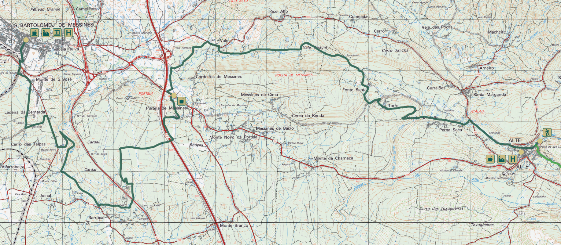
Alte, a picturesque traditional Algarve village, is full of whitewashed houses and decorated narrow streets. The route leads from the village through the rural Algarve barrocal, characterised by dry orchards of almond, carob and fig trees, small vegetable gardens and scattered houses. The path takes walkers through natural landscapes, along streams with rich riparian vegetation to the artisan village of Torre.
The route continues through Vale Gorge and climbs up to Portela de Messines, an area rich in vegetable gardens and traditional irrigation tools. In spring, the air is filled with the scent of orange blossom. A special part of the route is the walk along the banks of the Meirinho stream, a shady spot with extensive riparian vegetation.
The end point, São Bartolomeu de Messines, is a village steeped in history, nestled on the southern slope of Cerro Penedo Grande and on the edge of the Caldeirão Hills.
Via Algarviana Stage 9: Saint Bartholomew of Messines to Silves
Stage 9 of the Via Algarviana runs from São Bartolomeu de Messines to Silves and is 24.2 kilometers.
Stage 9 of the Via Algarviana starts at the main church in the centre of São Bartolomeu de Messines, passes the house of the famous poet João de Deus and crosses the whole town until reaching the railway line. Initially, the route follows a path surrounded by stone walls, passing through rural areas and a cork oak forest. After Barradas and crossing the EN 1079 road, the landscape changes considerably as it approaches the hills and the Arade stream. There are beautiful views of the river, its tributaries and the surrounding hills.
A picnic area in front of the Funcho Dam provides a perfect break, before a tough climb follows. The trail continues along the Arade Stream, deeper into the hills, passing eucalyptus forests, ponds, vegetable gardens and orchards, ending in historic Silves with its striking red sandstone castle and cathedral.
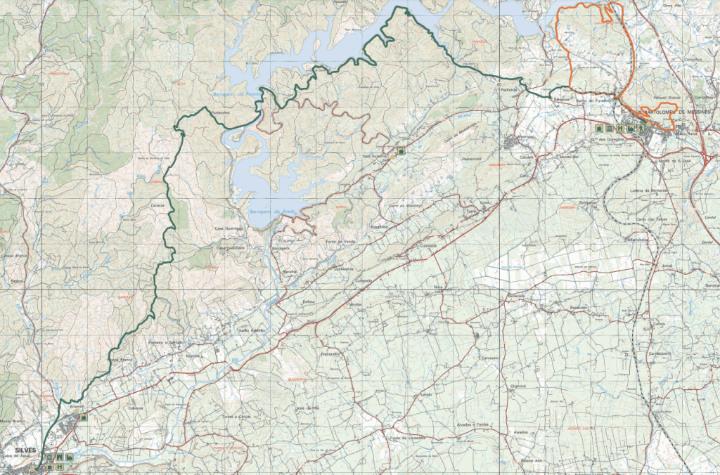
Via Algarviana Stage 10: Silves to Monchique
Stage 10 of the Via Algarviana runs from Silves to Monchique and is 32.1 kilometers.

The 10th sector of the Via Algarviana starts in Silves, known for its historic Moorish castle, old cathedral and orange groves. The route heads towards the Monchique Hills, through a varied landscape of cistus, eucalyptus and pine forests, and offers panoramic views over the vast hills.
Along the way you will pass abandoned farming villages and follow the Odelouca stream, which supports small farming communities. In this area the flora is more diverse near the water sources, with different herbs perfume the air. After a break at Fonte Santa, where an old thermal complex with hot springs can be found, the route climbs to Picota, the second highest point in the Algarve, with breathtaking views over the region and even as far as the Alentejo on clear days.
The tour ends in Monchique, where the dense cork oak forests give way to the charming town..
Via Algarviana Stage 11: Monchique to Marmelete
Stage 11 of the Via Algarviana runs from Monchique to Marmelete and is 14.8 kilometers.

Start from the Tourist Information Office and head towards Largo dos Chorões for a 3km climb through the narrow streets of Monchique. You will pass the ruined Nossa Senhora do Desterro Monastery and a cork oak forest with beautiful views over the town and Picota. The path leads through a dense eucalyptus forest to a municipal road, after which you will walk through a typical mountain landscape.
The route continues along a paved road to Fóia for panoramic views. Take a detour to the highest point in the Monchique Hills and Algarve (902 m) at Fóia. The route continues to Penedo do Buraco, passing through a valley of ancient agricultural terraces and small mountain villages, finally ending in Marmelete. The local economy here revolves around forestry, cork production, pig farming, beekeeping, production of “medronho” brandy and horticulture.
At the end, try a glass of “medronho” or “melosa” as a souvenir of this special experience.
Via Algarviana Stage 12: Marmelete to Bensafrim
Stage 12 of the Via Algarviana runs from Marmelete to Bensafrim and is 30 kilometers.

This stage starts in Marmelete and partly follows the PR6 MCQ – Marmelete Trail. After 1.7 km the Via Algarviana splits towards Aljezur, while the route towards Bensafrim turns south. The road has a varied landscape: eucalyptus forests, cork oak forests, agricultural areas and small villages, finally ending in a limestone-rich area with dense Mediterranean scrub.
Along the way you will pass some remote hamlets and restored country houses. At the Bravura Dam there is an opportunity for a break. The last part of the route runs through a fertile landscape with cork oaks, vegetable gardens, streams and stream valley vegetation, to finally reach Bensafrim via a wide river valley, where this stage ends.
Via Algarviana Stage 13: Bensafrim to Vila do Bispo
Stage 13 of the Via Algarviana runs from Bensafrim to Vila do Bispo and is 29.7 kilometers.

From the centre of Bensafrim, the route heads southwest to Barão de São João, the most rural part of the municipality of Lagos, known for its organic farming. The route begins through a typical barrocal landscape with dense Mediterranean scrub and a large cork oak forest, which adds shade and beauty to the route.
Barão de São João, known for its cultural and artistic atmosphere, welcomes visitors with local amenities and artwork in the streets. Beyond the village, the route passes through a large pine forest and back into the hills, with notable sites such as the Vinha Velha Valley and the Monte de São Lourenço. Near Sítio das Sesmarias, the landscape changes to a vast agricultural plateau, with Budens Lake, a small wetland area full of bird and amphibian species.
The path then approaches the Vincentine coast, offering the first views of the sea. The sector ends in Vila do Bispo, the start of the last stage.
Via Algarviana Etappe 14: Vila do Bispo near Cabo de São Vicente
Stage 14 of the Via Algarviana runs from Vila do Bispo to Cabo de São Vicente and is 16.4 kilometres.

The last stage of the Via Algarviana is located in the heart of the Southwest Alentejo and Vicentine Coast Natural Park, one of the most valuable protected areas in Portugal. Along the route you will discover unique coastal landscapes, endemic flora and perhaps even rare birds such as the red-billed chough and peregrine falcon. From the main church of Vila do Bispo, the route heads south, passing through abandoned fields and typical scrubland of the region. You will also come across livestock, as these areas are still used for grazing.
The route is fairly easy and mostly flat. Vila do Bispo is known for the largest concentration of megalithic monuments on the Iberian Peninsula. The route takes you past small settlements and interesting birdwatching areas, and crosses with the GR11 – Rota Vicentina.
Finally you reach Cabo de São Vicente, the westernmost point of Iberia, known for its sunsets and wild landscapes, where the Via Algarviana ends.
Will you conquer the Via Algarve?
Let me know in the comments if you have conquered the Via Algarve or are going to start this adventure. I am very curious about your experiences of this beautiful hike.
More of our local tips for your Portugal adventure
⭐ Check out our favourite sights in the Algarve on this page
⛵ Check out this overview of all activities you can do in the Algarve
🚗 This is the best car rental company in the Algarve
📌 Discover the top towns and cities to visit in the Algarve here
🏖 These are our favourite beaches in the Algarve
🛎 Get inspired with our local tips for accommodations in the Algarve
Magical Portugal
Welcome to Magical Portugal. Your #1 tourism guide to Portugal
Inspiration in your inbox
Highlights